
When drawing maps of continents, being realistic is a good idea even when inventing for a fantasy or SF landscape. We’re not freed from plausibility unless we’re purposely throwing out the laws of physics and nature. Most of us are probably creating reasonably Earth-like terrain, but even if not, there are natural forces at work on most planets.
The following tips can not only prevent mistakes but give world builders ideas. Sometimes we’re not sure where to put a forest or desert, or why. Maybe we’re not sure where to even begin. The answer is mountain ranges and a decision on which hemisphere our continent is on. This will determine prevailing winds and, as a result, vegetation. If you don’t understand why, read on.
Mountains and Rain Shadows
Mountains cause moisture-carrying winds to rise. The clouds dump all the rain on one side of the mountain range, causing plants and trees. On the mountain range’s other side, there’s no water left to fall. This causes a “rain shadow,” an area that receives little to no rainfall. Deserts are the usual result.
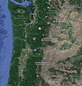
The below image of the western coast of the United States shows the sudden onset of desert on the eastern side of the Cascade Mountains, which are also causing the forests to their west. Not only is this not peculiar, but it’s a common and expected result that plays out across the Earth. Not knowing this, we might try to justify such a thing by saying a supernatural or technological event caused it when nature will do it.
A rain shadow can cover a huge area, such as the Great Plains of the United States. This isn’t a desert, but grasslands, but the same effect is responsible. The Rocky Mountains have taken much of the moisture out of the air, just not all of it. Some moisture is also coming up from the Gulf of Mexico to the south, so there’s enough rain to cause grass, just not lush vegetation. Generally, desert-like conditions occur closest to the mountains. As we progress farther from them, desert may give way to grasslands and finally forests.
How do we know which side has the desert or forest? We need to know about prevailing winds to answer that.
Prevailing Winds
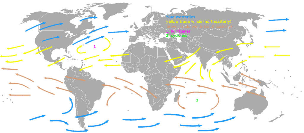
On a world that is spinning on its axis, like Earth, there will be winds. Which direction these winds flow depends on latitude (distance from the equator) and which way the planet is rotating. Earth rotates counterclockwise and in this article we’ll assume your world does, too; if not, then reverse every mention of direction made below.
On Earth, the rotation causes winds from the equator (0°) to the tropics (up to 40°) to travel east; on the map below, yellow and brown arrows indicate this. In the temperate zones (40°—66°), winds travel west, as indicated by the blue arrows on the map. In the polar zones, winds are again eastward but are light. On the first map above, this explains why the forest is on the westward side of the mountains: the wind is westerly.
No Deserts near the Equator
The world’s deserts aren’t within 30° of the equator due to an atmospheric phenomenon called Hadley cells (there is one in each hemisphere). This weather pattern means most deserts, especially the large ones like the Sahara, start around 30°.
It also means there’s heavy precipitation from 0°—30° and this is too much rain for deserts to form. There’s one exception to this, at least on Earth: Somalia is located at the equator and is mostly arid. The reason? The elevation is between 5-15,000 feet. This changes what would be a tropical climate into a temperate one, and that’s exactly where rain shadows cause deserts. In this case, the Himalayan Mountains are the likely culprit despite how far away they are.
Putting it Together
How can we use this information? We can follow these steps when planning and creating a continent map:
- Determine which hemisphere our continent is in, and how far from the equator (or even whether it spans it)
- Decide which parts of the land mass are in each latitude/climate zone, noting the prevailing wind direction:
- Between 0°—40°, winds are easterly
- Between 40°—66°, winds are westerly
- Add mountain ranges where desired
- Plan where your deserts and forests are:
- Between 0°—30°, no deserts except in highlands
- Between 30°—40° forests to the east of mountains, deserts to the west
- Between 40°—66°, forests to the west of mountains, deserts to the east
- Remember that a desert may give way to grasslands and then forests, farther from the mountains that cause a rain shadow. This can give us a line, from left-to-right (or right-to-left) of forest, mountains, desert, grassland, forest. This depends on mountains running north-to-south, as this is perpendicular to the wind direction and therefore blocks the winds. An east-to-west range may cause this but on a smaller scale.
Also, note that winds are westerly or easterly but not perfectly so. They move slightly toward or away from the equator, as the above image illustrates. We don’t need to be super picky about this, however, partly because the vast majority of people have no idea about any of this. We always have the caveat that no one from our imaginary world is going to show up on Earth and announce to our horror (and the delight of our critics) that there is, in fact, no desert or forest at a specific location despite what our map says.
We may not know where 40° latitude is on our maps, but as long as we’re in the ballpark, we’re okay. The goal is to be plausible, not necessarily right.
Hopefully all of this informs and inspires your work, rather than inhibits you. If you’d like to learn more such details, they can be found in my book, Creating Places (The Art of World Building, #2).
A Quiz
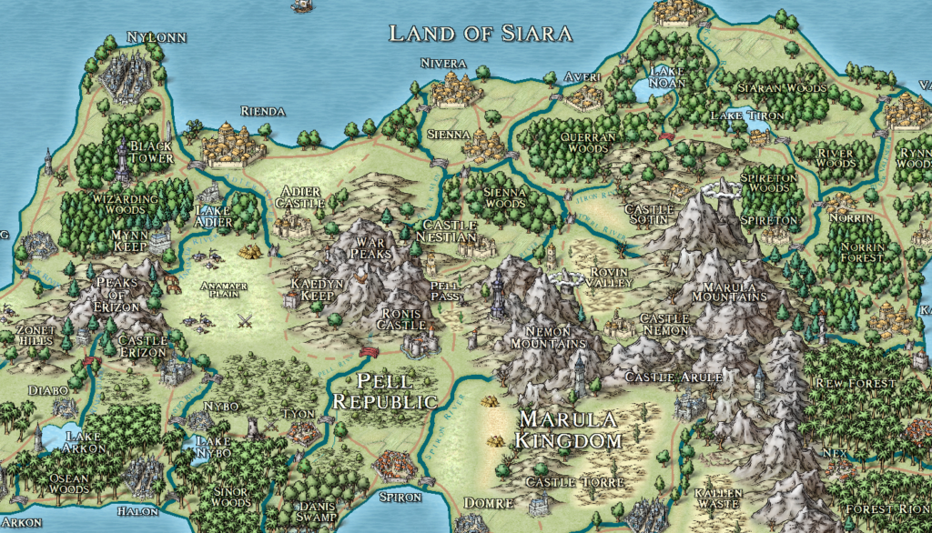
Based on the image below (from my world Llurien), see if you can answer these questions (answers at the article’s end):
Question #1: based on where mountains, forests, and deserts are, which direction are the prevailing winds?
Question #2: how far from the equator is this region?
Question #3: which hemisphere is it? (hint: look at the vegetation icons)
Question #4: If you know the answer to the first three questions, what explains the existence of the deserts on the bottom area of the map?
Quiz Answers
- east
- not very because easterly winds are nearer the equator
- this image is in the northern hemisphere. If we can see the tree icons (they’re a little small here), rainforest icons are used on the southern half, implying the equator is to the south (it’s just off the bottom edge of the map).
- since this is near the equator, there can’t be deserts, except that those areas of the map are above 5,000 feet (called the Marulan Highlands)) and are therefore a temperate climate. This lets the mountains on the right cause a rain shadow.